Department for Communities and Local Government, (2019) Diagram 11.7 Permitted unprotected areas in small residential buildings. [Image]
![[img]](https://www.buildvoc.co.uk/id/eprint/940/2/b-volume-1-diagram-11-7.jpg)
 Preview |
b-volume-1-diagram-11-7.jpg
Download (144kB) | Preview
![[img]](https://www.buildvoc.co.uk/style/images/fileicons/text.png) Text
Text
b-volume-1-diagram-11-7.docx
Restricted to Repository staff only
Download (7kB)
Text (Plain text conversion conversion from text to text/plain)
b-volume-1-diagram-11-7.txt
Restricted to Repository staff only
Download (187B)
![[img]](https://www.buildvoc.co.uk/id/eprint/940/11/b-volume-1-diagram-11-7.svg) Image
Image
b-volume-1-diagram-11-7.svg
Restricted to Repository staff only
Download (7kB)
Official URL: https://www.gov.uk/government/publications/fire-sa...
Abstract
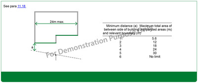
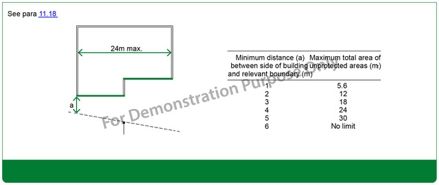
Minimum distance (a) between side of building and relevant boundary (m) Maximum total area of unprotected areas (m2)
See para 11.18
| Item Type: | Image |
|---|---|
| Additional Information: | mml-maui-text-analytics-keywords |
| Uncontrolled Keywords: | unprotected area, relevant boundary, boundary, boundary |
| Subjects: | Section 11: Resisting fire spread from one building to another B4: External fire spread Building standards |
| Date Deposited: | 14 Mar 2020 09:47 |
| Last Modified: | 29 Sep 2022 21:01 |
| URI: | https://buildvoc.co.uk/id/eprint/940 |
Actions (login required)

- View Item